
 |
 |
 |
 |
On Saturday, November 21st at 7:30 we left the house and headed towards Harrisonburg, Virginia. Our destination was the Dry River Ranger District of the George Washington National Forest for some light four-wheeling.
We arrived in Harrisonburg at 9:30 or so. It really surprised me how quickly you can get from Richmond to Harrisonburg with a V-8 (past trips were in a heavily modified Samurai -- slow on hills -- built mainly for offroad) and speed limits of 65 (which means I can drive 75 -- Shhh, don�t tell anyone.). First thing we did was to eat because we hadn�t eaten at the house do to a late start. After eating, Shoney�s on Rt 33, Carolyn (spousal unit) decided we need to fuel up before going in. I had half a tank but said OK and proceeded to find a place to get gas. I found some no name place with real gas (not an alcohol mix -- or whatever it is) for $0.79 and filled the tank. I noted that the place had a self service wash behind the station, which would make it the perfect place to return to after the run to wash the truck. We also picked up some munchies for an on the run lunch because once you get up into the mountains there is no coming back out without wasting at least an hour, if not more.
Now I�ve feed the party, feed the truck and appeased the spousal unit, time to hit the trail. We start by heading out US Rt 33 past Harrisonburg to VA Rt 612 and turn right. We follow that to some church on the left (can�t remember the name -- think it�s Baptist? Don�t bother telling me -- I won�t fix this. :-) We then turn left up Forest Road (FR) 72. See #1 on the map. As always, clicking on a picture gets a larger one.

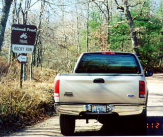
At the trailhead, I stopped to let the air out of the trucks tires and shift to 4-Low. This allows better traction and a smoother ride on the rocks. I took the pressure down to 15psi per wheel. This took a while so Carolyn, Zach and the dog (Bear) played a bit.


As you can see FR 72 runs up the side of a mountain and allows for some spectacular views in fall and summer -- not much to see in the fall and winter other than why it�s called the Blue Ridge Mountains. We drove up FR 72 to the intersections of Second Mountain Trail Road and Gauley Ridge Road (#2 on the map). Note that in the National Forests, large ORV�s (trucks and Jeeps) are only allowed to travel on roads so most roads that I mention are really just a road by name.
It wasn�t my original intention to go down Gauley Ridge Road but I turned right onto it anyway. We travelled down the road (the first real four-wheeling section) to a Jeep Trail/FR 240 and turned right (#3 on the map). I had my doubts as to whether or not I�d be taking this big truck down that little road, I remembered it being real tight in the Samurai pulling a trailer. We followed this road to a small handmade Boy Scout bridge and pulled into the small opening on the left (#4 on the map). We had previously camped in this location about 8 years ago and was dismayed to find out that the stream running next to the area was almost dry. Hopefully, that can be attributed to this year�s drought and that it will be running again next year. From here we did something I dislike doing, we turned around and backtracked because the road goes back out to the beginning of FR 72. When we got back to Gauley Ridge Road, I turned right and headed down the mountain. Since I wanted to go down Dictum Ridge Road (FR 442), I decided I would once again do something I disliked, and turned around again after a while. You can design runs so that you don�t have to turn around but because I didn�t really have anyone with us and didn�t have an agenda I found myself backtracking -- again and it wouldn�t even be the last time!


Light four-wheeling turned a little rough as I decided to take one of the alternate routes over a hill rather than around it.
I was extremely please with the trucks performance on this hill. It crawled right up the hill slowly with hardly any wheel spin. And yes, those steps do hit, I guess the trucks not yet tall enough. In the Samurai, I�d have had to nail it and bounce my way up the hill. Now that I�ve had a little fun it was time to find Dictum Ridge Road (#6 on the map).


This road was tight and rough as expected. There was even a mud puddle -- not the alternate route around it. Unfortunately, due to hunting season and private property we didn�t get to the end of the road (#7 on the map) and didn�t get to traverse the stair steps right before the road meets US Rt 33 -- At this time, I�m vowing that I will not backtrack again this trip. I need to contact the Ranger�s Station and find out if the Forest Service has the right to cross that land to get to the Forest Road. Back at Second Mountain Trail, I turned left and headed towards US Rt 33. We stopped several times on this road, mainly because the little guy woke up, imagine him sleeping through this stuff and to let the dog out.


As you can see from the pics above, I found a little more mud to splash through. Anyone that has been on this road before will recognize the shot below.

We continued down Second Mountain Trail Road until it met up with US Rt 33 (#8 on the map). At this point, I was disappointed that I decided to travel the road from north to south. The heavy rains in the spring caused massive soil runoff so the trail was mostly big (for VA) loose rocks that would be challenging to traverse. And I had already decided that I wasn�t going to backtrack again, so...
Once we hit US Rt 33, I turned left just to verify that my favorite and in my opinion, best road (#9 on the map), this one really is a trail no matter what they call it, was still closed. What makes it the best you ask? Because it�s very tight, very rocky and very steep, it climbs about 1100 ft in 6 miles. To my dismay it was. Had it been open, I�d have had to stay the night as it was way too late at this time to start that trail anyway.
Not having my fill yet, I headed for an area that is normally inhabitated by fisherman (#10 on the map). I say normally because the stream that is fished is dry and I don�t imagine that many fisherman actually fished in there this summer. The roads in the area which are normally muddy and filled with water were also bone dry. Let�s hope for a lot of snow and rain this winter so their can actually be water in the mountains next year.
In closing, I�d say we had a good time. The mountains were filed with many people, I was really surprised how many and don�t think I�ve ever seen that many 4WDs in the forest. These people were both hunters and four-wheelers. Now I just need to find some place to pay $80 to get rid of the brush scratches now on my truck. :-(
Update: I was able to remove the brush scratches myself. It took some time, about 5 hours, but with these 3M products, the Perfect-It Rubbing Compound and Perfect-It Paste Wax, I was able to get rid of all but about 1% of the brush scratches.
Please contact me with questions or comments.
© Copyright 1998, Edison Pettit, All rights reserved.